Go to Okinawa Electromagnetic Technology Center top page

Page 1 Wind Profile Radar (WPR) at the Ogimi Wind Profiler Facility (128° 09' 32" E, 26° 40' 41" N, 225 m MSL)Principles of Wind Profile Radar (WPR) Page 2 Time Domain Integration (Coherent Integration) Page 3 Frequency Domain Integration (Incoherent Integration) Page 4 Typhoon Nari, 2001 (09/07/2001, 11:22, 2.00 ms, 8 bits) Page 5 Typhoon Nari, 2001 (09/07/2001, 14:45, 2.00 ms, 8 bits) Page 6 Path of Typhoon Nari, 2001 Page 7 Time-Altitude Cross-section of Horizontal Wind Velocity Near Typhoon Nari, 2001 Page 8 Principles of RASS (Radio Acoustic Sounding System) Page 9 Altitude-Velocity Doppler-Spectrum Distribution in RASS Observation. Page 10 Virtual-Temperature Profile by RASS Observation (09/04/2001, 15:43-15:54) Page 11 Data Flow

Time Domain Integration (Coherent Integration)

Most radio waves pass through the atmosphere without significant attenuation; this is why radio (including radio broadcasts and mobile phone service) is such an effective means of communication. Wind profiler radar, on the other hand, relies on the detection of radio waves scattered by subtle atmospheric turbulence; the device must therefore be equipped to receive weak radio signals. The WPR thus features digital signal-processing to increase sensitivity by reducing the effects of noise.

This figure presents a time chart for the radar's transmission and reception of pulsed radio waves. The horizontal and vertical axes represent time and distance between the antenna and the scatterer, respectively.

With coherent integration, the acquired signal (a complex time series signal obtained by orthogonal detection) is integrated over a time domain for a period during which the scatterer is assumed to be coherent (i.e., keeping a steady wave structure). The amplitude of the signal is x nc, so the power is x nc2. On the other hand, the power of the white noise in this case is x nc; consequently the signal-to-noise ratio (SNR) is x nc.
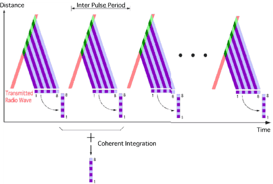
Time Domain Integration (Coherent Integration)
Site MapUpdatesInformationHistoryOutline of Organization - Introduction to Researchers - PublicationsOkinawa Electromagnetic Technology Center Virtual MuseumFacility MapIonospheric ObservationGround-based Meteorological Observation SystemThe Computer Network System for Subtropical Environment Monitoring RainNICT Okinawa Bistatic Polarimetric Radar (COBRA) Nago Precipitation Radar Facility and Bistatic Receiver StationWinds 400-MHz/1.3-GHz Wind Profiler Ogimi Wind Profiler Facility OceanLong-Range Ocean Radar Ishigaki/Yonaguni Ocean Radar Facility