Go to Okinawa Electromagnetic Technology Center top page

[ Page1 ]What is COBRA? /Development purpose of COBRA [ Page2 ]Features of COBRA [ Page3 ]Locations of the COBRA system and Network Link/Main specifications of the COBRA main radar [ Page4 ]Principles of Bistatic Radar Network [ Page5 ]dvantages of a Bistatic Radar Network [ Page6 ]Area of Bistatic Radar Network Observation [ Page7 ]Signal processing/Data Validation [ Page8 ]Operational mode/Example of COBRA Observation

Area of Bistatic Radar Network Observation

The solid black outer circle indicates the 150-km observation range of the main radar. The black lines on the inside represent the observable ranges for the bistatic Doppler radars that can be deployed at present. The green and red lines indicate the areas where bistatic Doppler observations will be possible when bistatic receivers are installed on Yoron Island and Itoman.
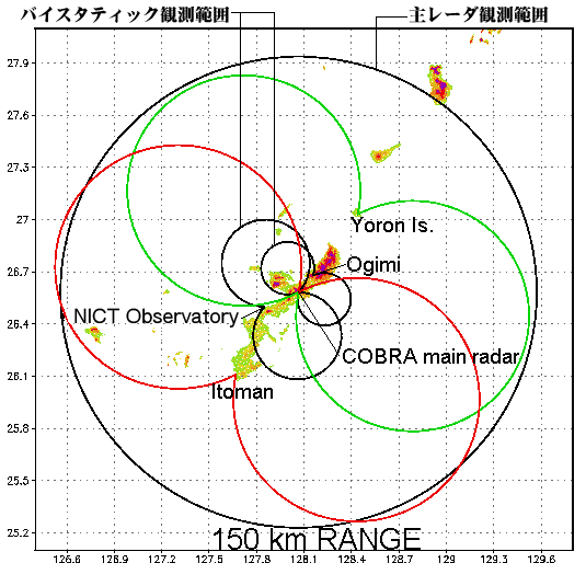
Area of Bistatic Radar Network Observation

Return to previous page

[ Page1 ]What is COBRA? /Development purpose of COBRA [ Page2 ]Features of COBRA [ Page3 ]Locations of the COBRA system and Network Link/Main specifications of the COBRA main radar [ Page4 ]Principles of Bistatic Radar Network [ Page5 ]dvantages of a Bistatic Radar Network [ Page6 ]Area of Bistatic Radar Network Observation [ Page7 ]Signal processing/Data Validation [ Page8 ]Operational mode/Example of COBRA Observation

Link-Map

Go to Okinawa Electromagnetic Technology Center top page
Site MapUpdatesInformationHistoryOutline of Organization - Introduction to Researchers - PublicationsOkinawa Electromagnetic Technology Center Virtual MuseumFacility MapIonospheric ObservationGround-based Meteorological Observation SystemThe Computer Network System for Subtropical Environment Monitoring RainNICT Okinawa Bistatic Polarimetric Radar (COBRA) Nago Precipitation Radar Facility and Bistatic Receiver StationWinds 400-MHz/1.3-GHz Wind Profiler Ogimi Wind Profiler Facility OceanLong-Range Ocean Radar Ishigaki/Yonaguni Ocean Radar Facility