Go to Okinawa Electromagnetic Technology Center top page

HF Ocean Radar Applications of HF Ocean Radar Examples of Observed Current Vectors Using HF Ocean Radar Development of Long-Range Ocean Radar Characteristics of Long-Range Ocean Radar and Propagation Losses of 9.2 MHz and 24.5 MHz Long-Range Ocean Radar and NICT Ocean Monitoring Platform in Sakishima (COMPASS) Antenna System of Long-Range Ocean Radar Block diagram of Long-Range Ocean Radar system Example of Observed Current Vectors Using Long-Range Ocean Radar

Example of Observed Current Vectors
Using Long-Range Ocean Radar
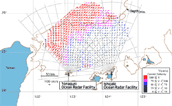
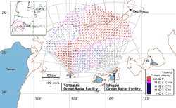
Fig. 1 Example of Observed Current Vectors Using Long-Range Ocean Radar
Fig. 107/24/2001 12:00 Fig. 1 Example of Observed Current Vectors Using Long-Range Ocean Radar
Fig. 2 Example of Observed Current Vectors Using Long-Range Ocean Radar
Fig. 209/16/2001 09:30Fig. 2 Example of Observed Current Vectors Using Long-Range Ocean Radar

Figure 1 shows current vectors observed at 12:00 on July 24, 2001. It is clearly shown that the Kuroshio current flowing into the East China Sea from the area between Yonaguni Island and Taiwan turns east near the continental shelf.

Figure 2 shows current vectors observed at 09:30 on Sept. 16, 2001. This is the very time when Typhoon Nari was passing through the area. There was a very fast eddy-like current that seemed to be induced by the strong winds of the typhoon. This eddy-like current gradually moved to the southwest from the night of Sept. 15 to the evening of Sept. 16.


Return to previous page

HF Ocean Radar Applications of HF Ocean Radar Examples of Observed Current Vectors Using HF Ocean Radar Development of Long-Range Ocean Radar Characteristics of Long-Range Ocean Radar and Propagation Losses of 9.2 MHz and 24.5 MHz Long-Range Ocean Radar and NICT Ocean Monitoring Platform in Sakishima (COMPASS) Antenna System of Long-Range Ocean Radar Block diagram of Long-Range Ocean Radar system Example of Observed Current Vectors Using Long-Range Ocean Radar

Link-Map

Go to Okinawa Electromagnetic Technology Center top page
Site MapUpdatesInformationHistoryOutline of Organization - Introduction to Researchers - PublicationsOkinawa Electromagnetic Technology Center Virtual MuseumFacility MapIonospheric ObservationGround-based Meteorological Observation SystemThe Computer Network System for Subtropical Environment Monitoring RainNICT Okinawa Bistatic Polarimetric Radar (COBRA) Nago Precipitation Radar Facility and Bistatic Receiver StationWinds 400-MHz/1.3-GHz Wind Profiler Ogimi Wind Profiler Facility OceanLong-Range Ocean Radar Ishigaki/Yonaguni Ocean Radar Facility