Go to Okinawa Electromagnetic Technology Center top page

Page 1 Wind Profile Radar (WPR) at the Ogimi Wind Profiler Facility (128° 09' 32" E, 26° 40' 41" N, 225 m MSL)Principles of Wind Profile Radar (WPR) Page 2 Time Domain Integration (Coherent Integration) Page 3 Frequency Domain Integration (Incoherent Integration) Page 4 Typhoon Nari, 2001 (09/07/2001, 11:22, 2.00 ms, 8 bits) Page 5 Typhoon Nari, 2001 (09/07/2001, 14:45, 2.00 ms, 8 bits) Page 6 Path of Typhoon Nari, 2001 Page 7 Time-Altitude Cross-section of Horizontal Wind Velocity Near Typhoon Nari, 2001 Page 8 Principles of RASS (Radio Acoustic Sounding System) Page 9 Altitude-Velocity Doppler-Spectrum Distribution in RASS Observation. Page 10 Virtual-Temperature Profile by RASS Observation (09/04/2001, 15:43-15:54) Page 11 Data Flow

Time-Altitude Cross-Section of Horizontal Wind Velocity Near Typhoon Nari, 2001

The figure below shows the temporal changes in the altitude distribution of horizontal winds from Sept. 7 to Sept. 8, 2001, during the approach of typhoon Nari. The vertical axis represents the height above the radar, from 0 to 18 km.

Wind velocity below 8 km was greatest from 18:00 on Sept. 7 to 9:00 on Sept. 8, when the typhoon was closest, while wind direction changed over time as easterly winds gave way to southerly winds. The maximum observation altitude was situated near the center of the typhoon, at 17 km. As humidity decreased after the typhoon passed, maximum altitude was reduced to approximately 12 km. Since then, adjustments have been made to the radar, and presently the average limit to observation altitude is approximately 13 km.
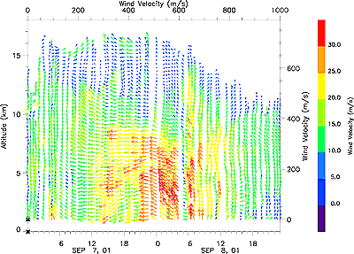

Time-Altitude Cross-Section of Horizontal Wind Velocity Near Typhoon Nari, 2001

100KB/GIF-file
100KB


1000KB/GIF-file
1000KB

Site MapUpdatesInformationHistoryOutline of Organization - Introduction to Researchers - PublicationsOkinawa Electromagnetic Technology Center Virtual MuseumFacility MapIonospheric ObservationGround-based Meteorological Observation SystemThe Computer Network System for Subtropical Environment Monitoring RainNICT Okinawa Bistatic Polarimetric Radar (COBRA) Nago Precipitation Radar Facility and Bistatic Receiver StationWinds 400-MHz/1.3-GHz Wind Profiler Ogimi Wind Profiler Facility OceanLong-Range Ocean Radar Ishigaki/Yonaguni Ocean Radar Facility