Go to Okinawa Electromagnetic Technology Center top page

Page 1 Wind Profile Radar (WPR) at the Ogimi Wind Profiler Facility (128° 09' 32" E, 26° 40' 41" N, 225 m MSL)Principles of Wind Profile Radar (WPR) Page 2 Time Domain Integration (Coherent Integration) Page 3 Frequency Domain Integration (Incoherent Integration) Page 4 Typhoon Nari, 2001 (09/07/2001, 11:22, 2.00 ms, 8 bits) Page 5 Typhoon Nari, 2001 (09/07/2001, 14:45, 2.00 ms, 8 bits) Page 6 Path of Typhoon Nari, 2001 Page 7 Time-Altitude Cross-section of Horizontal Wind Velocity Near Typhoon Nari, 2001 Page 8 Principles of RASS (Radio Acoustic Sounding System) Page 9 Altitude-Velocity Doppler-Spectrum Distribution in RASS Observation. Page 10 Virtual-Temperature Profile by RASS Observation (09/04/2001, 15:43-15:54) Page 11 Data Flow

Typhoon Nari, 2001

These figures show the Doppler spectrum obtained during the approach of typhoon Nari in 2001, when there was no precipitation. In the three top figures the directions of the radar antenna beam are vertical, north, and south (as shown from left to right), and in the bottom two figures, the directions are east and west. Except for the vertical beam, the beams are all inclined at a zenith angle of 10.5°. The horizontal axis represents the Doppler velocity, and the center peak is the signal component of the ground clutter. The color scale represents the intensity of the scattered signals. The peak exhibits shifts to the right and left at different heights due to variations in wind velocity. The vertical axis represents distance from the antenna; signals can be received from a maximum distance of 16 km.

(09/07/2001 11:22 2.00 ms 8 bits)
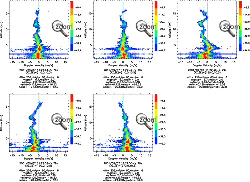
Typhoon Nari(09/07/2001 11:22 2.00 ms 8 bits)
Typhoon Nari, 2001 5Typhoon Nari, 2001 4Typhoon Nari, 2001 3Typhoon Nari, 2001 2Typhoon Nari, 2001 1Site MapUpdatesInformationHistoryOutline of Organization - Introduction to Researchers - PublicationsOkinawa Electromagnetic Technology Center Virtual MuseumFacility MapIonospheric ObservationGround-based Meteorological Observation SystemThe Computer Network System for Subtropical Environment Monitoring RainNICT Okinawa Bistatic Polarimetric Radar (COBRA) Nago Precipitation Radar Facility and Bistatic Receiver StationWinds 400-MHz/1.3-GHz Wind Profiler Ogimi Wind Profiler Facility OceanLong-Range Ocean Radar Ishigaki/Yonaguni Ocean Radar Facility