Go to Okinawa Electromagnetic Technology Center top page

Page 1 Wind Profile Radar (WPR) at the Ogimi Wind Profiler Facility (128° 09' 32" E, 26° 40' 41" N, 225 m MSL)Principles of Wind Profile Radar (WPR) Page 2 Time Domain Integration (Coherent Integration) Page 3 Frequency Domain Integration (Incoherent Integration) Page 4 Typhoon Nari, 2001 (09/07/2001, 11:22, 2.00 ms, 8 bits) Page 5 Typhoon Nari, 2001 (09/07/2001, 14:45, 2.00 ms, 8 bits) Page 6 Path of Typhoon Nari, 2001 Page 7 Time-Altitude Cross-section of Horizontal Wind Velocity Near Typhoon Nari, 2001 Page 8 Principles of RASS (Radio Acoustic Sounding System) Page 9 Altitude-Velocity Doppler-Spectrum Distribution in RASS Observation. Page 10 Virtual-Temperature Profile by RASS Observation (09/04/2001, 15:43-15:54) Page 11 Data Flow

Path of Typhoon Nari, 2001

In 2001, typhoon Nari remained near the main island of Okinawa for a long period of time. The center of the typhoon did not pass over the Ogimi Wind Profiler Facility, where the wind profiler is located. Instead, it passed 40 km south of Ogimi.
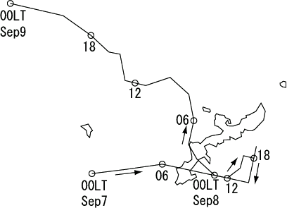
Path of Typhoon Nari, 2001
Site MapUpdatesInformationHistoryOutline of Organization - Introduction to Researchers - PublicationsOkinawa Electromagnetic Technology Center Virtual MuseumFacility MapIonospheric ObservationGround-based Meteorological Observation SystemThe Computer Network System for Subtropical Environment Monitoring RainNICT Okinawa Bistatic Polarimetric Radar (COBRA) Nago Precipitation Radar Facility and Bistatic Receiver StationWinds 400-MHz/1.3-GHz Wind Profiler Ogimi Wind Profiler Facility OceanLong-Range Ocean Radar Ishigaki/Yonaguni Ocean Radar Facility